4-Day Itinerary in the Aire and Candeeiros Mountains Natural Park
- Catarina Araújo

- May 1, 2025
- 13 min read
Updated: Dec 7, 2025
The Aire and Candeeiros Mountains Natural Park

Located in the heart of Portugal, the Aire and Candeeiros Mountains Natural Park is considered the most important limestone formation deposit in Portugal. It hides a fascinating underground world, where water flows through an intricate network of hidden channels, feeding mysterious caves and unique landscapes sculpted over millennia. In its many caves lives a wide variety of species, among which several species of cave-dwelling bats stand out — the symbol of this protected area.
The park encompasses the Estremenho Limestone Massif and stretches across several municipalities, namely Alcanena, Alcobaça, Ourém, Porto de Mós, Rio Maior, Santarém, and Torres Novas. To the west rises the long Candeeiros Mountain, while to the east lies the Aire Mountain.
The park's landscape is rugged and marked by a scarcity of surface watercourses. However, this aridity is contrasted by the natural magic of a territory shaped by karst erosion, where one can find impressive formations such as poljes, lapiaz fields, caves, sinkholes, uvalas, and dolines. It is a true paradise for geology and speleology enthusiasts, with more than 130 caves identified.
In this article, we share some of our favorite spots in the Aire and Candeeiros Mountains Natural Park and suggest a 4-day itinerary, perfect for a long weekend or a short getaway through this beautiful region.
Day 1 - Alcobertas and Rio Maior Salt Pans
The itinerary of the first day is marked by a walk between Chãos and Alcobertas, followed by a visit to the Rio Maior Salt Pans.
Chãos - Alcobertas Trail

The trail begins at the picturesque Chãos Weaving Center, an old forest house now dedicated to the ancient art of weaving. The small village of Chãos, with its walled fields and centuries-old cisterns, showcases the ingenuity of the mountain people, who have made the scarcity of water an art of survival. The Terra Chã Cooperative has been promoting the restoration and revitalization of rural heritage structures. Don’t miss visiting the Chãos Cultural Center, which houses the Arts and Crafts Center and a regional restaurant.


As you descend to Alcobertas, you will feel the pull to dive into history with a visit to the imposing Dolmen-Chapel, unique in Portugal. The Alcobertas Dolmen is a Neolithic funerary megalithic monument (c. 4000–3500 BC), and one of the largest on the Iberian Peninsula. Later, it was adapted for Christian worship and transformed into a chapel dedicated to Saint Mary Magdalene, with the addition of a roof in the 17th/18th centuries. For a guided tour inside the monument, contact the Rio Maior City Hall.


The trail also takes you to see the silos carved into the rock, used to store cereals for centuries. Further ahead, you will find the Olho d'Água das Alcobertas, a crystal-clear spring where time seems to slow down — it’s a great spot to relax, have a picnic, and perhaps chat with locals who still wash clothes there as they did in the past.


Next, there’s a challenging climb through the Vale Galego, where you can spot limestone cliffs and lapas, in a location known as Penas de Andorinha. Continuing the ascent, you will reach the ridge of the Candeeiros Mountain Range, at an altitude of 487 meters. Take a deep breath and enjoy the stunning views all the way to the Atlantic coast — Peniche, Nazaré, and even the Berlengas!


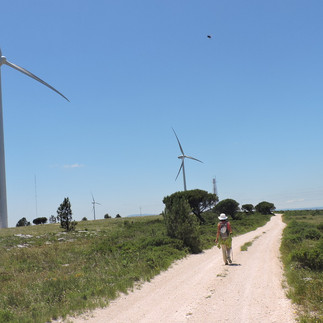
The landscape here is characterized by rocky outcrops. Stay alert for birdwatching, with a particular focus on the red-billed choughs, although their numbers have been decreasing.
Start of the trail: Chãos Cultural Center |
Distance: 16 km |
Difficulty level: medium+ |
Rio Maior Salt Pans - Salt Without the Sea

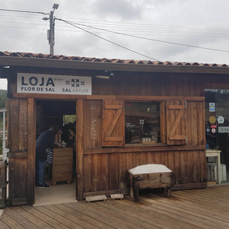
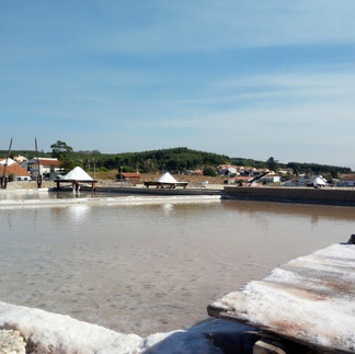
At the end of the trail, we suggest a visit to the Rio Maior Salt Pans. You can have lunch at the Salarium restaurant, enjoy the regional cuisine, and take a guided tour of the salt pans. The space also features a relaxing lounge and a shop selling regional products (Flor de Sal).


In Portugal, the Rio Maior Salt Pans are the only inland salt pans still in operation, with a history spanning around 8 centuries. Located about 30 km from the sea, in the Aire and Candeeiros Mountains Natural Park, these salt pans originated from a subterranean rock salt deposit formed millions of years ago. The water extracted from a local well is seven times saltier than seawater, allowing for salt production without the need for coastal proximity.
The wooden huts, structures that were once used for storing salt, now house cafés, restaurants, and shops selling local handicrafts and products derived from salt extraction.
These natural salt pans are located in a typhonic valley – a valley formed due to the rise of a salt complex. In this case, the valley is the result of the easy erosion of salt deposited during the Jurassic period, which is less resistant than the surrounding rocks and those deposited on top of this salt.


Day 2 - Porto de Mós and Bezerra Mines Trail
On the second day, head to Porto de Mós. This town is located in the center of the Natural Park, in a valley between the Candeeiros Mountains and the Aire Mountain Range.
The toponymic origin of Porto de Mós is related to the ancient Pedreira do Figueiredo, a limestone quarry from which stones were extracted to make millstones used in traditional windmills. Porto de Mós was the place where millstones were manufactured and transported via the Lena River, which was once believed to be navigable.
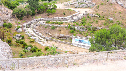
Visit to the Porto de Mós Castle
The main tourist attraction in Porto de Mós is its palace-style castle. It is a building of unique architecture, with Gothic and Renaissance influences. Shaped in a pentagonal plan, it stands out for its turrets and the green pyramid-shaped domes on the main façade.
After playing a very important role in the Christian reconquest and the defense of the kingdom, and having been gifted to Queen Santa Isabel by King D. Dinis, it was in the hands of D. Afonso (grandson of King D. João I and 2nd Duke of Bragança) that the former medieval defensive structure was transformed into a residential palace. As a cultured and well-traveled man, he carried out several restoration works under the Renaissance influences that were beginning to emerge in Europe.
Damaged by the 1755 earthquake, the castle underwent several restoration campaigns, the most recent one in 1999. Since 1910, it has been classified as a National Monument. Currently, the castle hosts various cultural events and has its own program, including exhibitions, concerts, theater performances, and conferences.
The Porto de Mós Castle offers the "Stories and Legends of a Unique Castle" route, a self-guided tour accessible through a web app on the visitor’s smartphone. Through this platform, it is possible to better explore the castle, guided by a narrative led by Queen Santa Isabel, which highlights the main points of the monument and shares interesting facts.

Bezerra Mines Trail
We now invite you to discover another walking trail, starting in the village of Bezerra.


The trail mostly follows the path of the old railway line that once transported coal from the Bezerra mines to Porto de Mós. It has now been converted into a modern eco-path, the Ecopista da Corredoura, making it an ideal infrastructure for walking, cycling, or running, while simultaneously providing a rich experience in observing the region's biodiversity and geomorphological diversity. Along the Ecopista da Corredoura, you will also find observation stations and viewpoints – perfect spots to enjoy the tranquility and beauty of this area.
The Serra da Pevide, located in the northern sector of the Candeeiros Mountain Range, stands out in the landscape. This area once hosted significant coal mining activity, now deactivated and not recommended for visits due to safety reasons.
The railway line, built to facilitate coal transport, followed an irregular route, necessary to overcome the mountain’s elevation changes. As you move forward, the environment begins to change: rock walls cut to make way for the trains now form shadowy tunnels.
At a high point in the Candeeiros Mountains, windmills crown the ridge. Here, a pleasant picnic area invites you to take a refreshing break before descending along the lower track. The trail continues through a stretch of Portuguese oak that extends from the hillside down into the valley, offering shade and coolness along the way.


The Sítio do Elias (Elias' Place) is a wooden hut built by the hands of Mr. José Elias, who kindly shares it with all those passing by on foot or by bike, stopping for a snack.


The Bezerra Mines Trail is home to a wide variety of animals.
Starting point: Next to the Bezerra Football Field |
Length: 12 km |
Difficulty: Medium |
Day 3 – Olhos de Água do Alviela + Dinosaur Footprints Natural Monument of Serra de Aire
Today is the day to visit the Municipality of Alcanena and discover one of the most fascinating geosites in the Serra de Aire e Candeeiros Natural Park: the Olhos de Água do Alviela (Alviela Spring).
This site is particularly important for its karst spring, one of the largest in Portugal, and for the complex underground system that includes caves, galleries, and natural conduits carved by water over thousands of years. It is a remarkable example of karst landscape in Portugal, featuring phenomena such as resurgences, sinkholes, and underground channels, typical of limestone regions.
Olhos de Água – Springs of the Alviela River
The Olhos de Água do Alviela spring is recognized as the largest karst spring in Portugal, with a flow that can reach 17,000 liters per second, or 1.5 million cubic meters of water per day during periods of high rainfall. It is a permanent spring, formed by the infiltration of rainwater into the Estremenho Limestone Massif, which is then carried through a complex system of underground galleries until it resurfaces. The spring’s flow is directly influenced by rainfall in its recharge basin, which covers an area of approximately 180 km².
The Alviela spring once supplied water to the city of Lisbon!
“The high flow rates, the quality of the water, and its proximity to Lisbon earned it the role of being the capital’s main water source from 1880 until quite recently.”
The Amiais stream flows through the landscape surrounding the spring, disappears into a cave, and reemerges 250 meters later in a narrow valley, where it joins the spring. At the base of the cliff, there is a small dam that captures water for public distribution, just above which lies the entrance to the Alviela cave.
Olhos d’Água do Alviela Interpretative Trail – PR1 ACN
The Olhos de Água do Alviela Interpretative Trail, approximately 2 km long, offers visitors the opportunity to explore various geological phenomena typical of karst areas, providing a truly unique experience.
The trail runs from the Alviela spring to the sinkhole of the Amiais stream. The Amiais stream, one of the rare surface watercourses of the Estremenho limestone massif, forms geological structures of rare beauty.
Through a karst window, an important natural structure, we can observe the stream circulating in depth and various levels of limestone caves formed over millions of years. These caves now serve as an important shelter for a colony of bats, functioning as a maternity site of special importance for the species.
Before joining the Alviela River, the Amiais stream reemerges at the surface and flows through a narrow and deep valley with steep slopes – the fluvial-karst canyon – which is undoubtedly an impressive sight. Right at the beginning of this valley is the Poço Escuro (Dark Well), a natural cavity that, during the rainy season, releases water with great force, demonstrating how the limestone massif is a large reservoir of groundwater.


Points of Interest
Alviela River Spring;
Poço Escuro;
Fluvial-Karst Canyon of the Amiais Stream;
Sinkhole of the Amiais Stream;
Karst Window;
Resurgence of the Amiais Stream.
The Alviela River, which, within the first few meters of its course, offers us the beautiful Olhos d'Água do Alviela River Beach.
Olhos d'Água River Beach
The Olhos d'Água do Alviela River Beach, next to the Alcanena Camping Park, is a refreshing and pleasant place to visit in the summer, for those who want to bathe in the cool waters of the Alviela River. It was renovated in 2016, with new features such as a children's playground, a playing field, grassy areas, a picnic area with a barbecue and a bar/restaurant.


Centro Ciência Viva do Alviela (Alviela Live Science Center) - Karstoscope
Opened in 2007, the Alviela Live Science Center is a space dedicated to the dissemination of science and technology, created with the purpose of valuing the rich natural heritage of the source of the Alviela River and its surroundings. In addition to promoting scientific knowledge, the Center plays an important role in environmental education. Topics such as bats, water and karst are addressed through interactive exhibits and activities designed for different audiences, making the visit an educational, dynamic and accessible experience for all ages.
The Night of the Bats
The Alviela Live Science Center organizes an annual activity as part of the 'Ciência Viva no Verão' (Live Science in Summer) project, which involves observing cave-dwelling bat colonies in the Alviela caves using infrared cameras. The group then gathers at the cave entrance to watch the bats emerge to hunt and, with the help of an ultrasound detector, identify the different species.
The Alviela Bat Night is an educational and scientific initiative aimed at raising public awareness about the importance of bats in ecosystems and promoting their conservation, while also offering a unique nocturnal observation experience.
Travel back to the time of the dinosaurs in Serra de Aire
In the heart of the Serras de Aire e Candeeiros Natural Park, about 10 km from Fátima, lies one of the world’s most remarkable paleontological treasures: the Natural Monument of the Dinosaur Footprints of Ourém / Torres Novas. This unique site is home to the largest and most important deposit of sauropod dinosaur footprints from the Middle Jurassic period, dating back approximately 175 million years.
Discovered by chance in an old quarry — the famous Pedreira do Galinha — these footprints are impressive not only for their size, which can reach up to 95 cm in length and 70 cm in width, but also for the clarity and extent of the trackways, some of which stretch for over 140 meters, ranking among the longest ever identified worldwide.
These marks were left by sauropods, massive herbivorous dinosaurs with bulky bodies, small heads, strong legs, and long necks and tails. They lived in tropical and humid environments at a time when the continents were beginning to drift apart and the landscape was dominated by shallow lagoonal plains. The footprints were imprinted in layers of limestone mud which, after drying and being covered by sediments, fossilized and have withstood the passage of time to the present day.
Here, you can follow the educational trail along the paths of the dinosaurs, learn more about their way of life, and admire the magnificent Jurassic Garden, where plants known as “living fossils” grow — such as tree ferns, cycads, araucarias, ginkgo, junipers, yews, and horsetails — species that already existed in the age of the dinosaurs.
This is a true open-air museum and a must-visit destination for the whole family. It’s a genuine journey into the past that invites us to reflect on the grandeur of Earth and the history of life that once inhabited it.


Day 4 - Explore the underground of Serra de Aire and Candeeiros
In the deep underground of the Serra de Aire and Candeeiros Natural Park, there lies a true subterranean world full of natural history and beauty. A wide variety of caves and sinkholes, shaped over millennia by the action of water, now captivate spelunking enthusiasts with their unique formations.
Some of these underground wonders, such as the Santo António Caves, Moeda Caves, Mira d'Aire Caves, and Alvados Caves, have been adapted to welcome visitors, offering various supporting infrastructures.
Mira D'Aire Caves
Elected as one of the "7 Natural Wonders of Portugal", the Mira D'Aire Caves feature several rooms and galleries of impressive dimensions and natural, imposing beauty. The total route is 11 km, but only the first 600 meters are open to the public. It is the largest cave in Portugal open to the public.
It is a site of great interest for studies and speleological research. The first explorers descended through a small gallery in 1947, but it was only after several years that they managed to discover the secret to continue progressing through the cave. Expeditions continued in the 1950s and 1960s, and the cave's topographic survey was completed.
In 1974, it was opened to the public. To promote tourism and make this natural wonder more accessible, hundreds of meters of wooden walkways and stairs were constructed, creating a visitable route leading to the "Siphon of Sands" chamber.
During the visit, it is possible to see underground watercourses and small ponds formed by the infiltration of rainwater over thousands of years. This presence of water was, in fact, one of the main factors responsible for the formation of the impressive stalactites and stalagmites that adorn the cave.
Near the entrance complex of the Mira D'Aire Caves and at the top of the Garden of Rocks, the Fossil Museum displays some of the specimens "rescued" from the parking lot of the Mira D'Aire Caves. The fossils are specimens from the nearby Jurassic beach of São Bento.
It is also possible to take a guided tour with a speleologist through a parallel gallery outside the regular tourist route, or to experience the Journey to the Center of the Earth tour, which follows the same tourist path but without lighting (headlamps are provided to visitors).

Here is the contact for booking: geral@grutasmiradaire.com.
Alvados Caves
The Alvados Caves are located near the village of Alvados, in the heart of the Serra de Aire and Candeeiros Natural Park. They were discovered in 1964 by local workers, revealing impressive limestone formations such as stalactites, stalagmites, and natural columns that give the space an almost magical beauty.
With around 300 meters of visitable length, the caves offer visitors an immersive experience, enhanced by a lighting system that highlights the rock formations. The route is made along walkways and stairs harmoniously integrated into the natural space, guiding visitors through narrow passages and a subterranean lake, one of the highlights of the visit. The exploration is carried out with the accompaniment of guides, making the experience even more enriching.
Santo António Caves
The Santo António Caves are located very close to the Alvados Caves, near the village of São Mamede, in the municipality of Porto de Mós. They were discovered in 1955 by a five-year-old boy who, while following a crow, came across an opening in the rock that led to an extensive underground system.
The caves feature limestone formations such as stalactites, stalagmites, and draperies, with a highlight being a large central chamber adorned with tall formations. The visitable length is around 350 meters, and guided tours are available to the public.
During the visit, it is also possible to observe natural lakes and enjoy a constant temperature between 16 °C and 18 °C, maintained by a natural chimney that allows air circulation.
Algar do Pena
Algar do Pena is a vertically developed cave that contains the largest known underground chamber in Portugal, where a wide variety of speleothems can be observed.
Opened to the public in 1997, and equipped with a technical support building, elevator, an open-air auditorium, and a speleodrome, this cave offers a unique underground exploration experience, combining scientific value with a strong educational and touristic component.
It was discovered in 1985 by Joaquim Pena — after whom the cave was named — during limestone extraction work for paving stones. Due to its location and natural features, it was chosen to host Portugal’s first Underground Interpretation Center.


CISGAP - Underground Cave Interpretation Center - Algar do Pena
Visits by prior reservation only and subject to the Center's availability.
email:pnsac@icnf.pt
243 999 480
Other places to visit
Finally, in a "bucket list" style, we leave here a mention of some places we haven't had the chance to visit yet, which will be saved for a future visit and a new blog post. These are locations that stand out for their geological, cultural, and natural interest, and they provide even more reasons to visit the Serra de Aire and Candeeiros Natural Park.
Fórnea Waterfall
Roman Road of Alqueidão da Serra
Mira Minde Polje
São Bento Jurassic Beach
If you've made it this far, thank you for your time, and see you in the next article of GPS da Quimera.


Comments